Home > Europe > United Kingdom > Wales > Maps
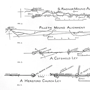
Ley lines: Radnor Vale, Wales

![]()
Wall Art and Photo Gifts from Mary Evans Picture Library
Ley lines: Radnor Vale, Wales
Map showing the eastern end of Radnor Vale, Wales, with the ley lines drawn in by hand. Date: 1925
Mary Evans Picture Library makes available wonderful images created for people to enjoy over the centuries
Media ID 14405880
© Mary Evans Picture Library
FEATURES IN THESE COLLECTIONS
> Europe
> United Kingdom
> Wales
> Maps
> Europe
> United Kingdom
> Wales
> Posters
> Europe
> United Kingdom
> Wales
> Related Images
> Maps and Charts
> Wales
EDITORS COMMENTS
1. Title: "Ley Lines of Radnor Vale, Wales: A 1925 Hand-Drawn Map Revealing Ancient Energy Lines" This image showcases an intriguing map of Radnor Vale in Wales, dated 1925. The eastern end of the valley is depicted, with the meandering River Wye flowing through it. What sets this map apart from others is the delicate addition of ley lines, drawn by hand. Ley lines are believed to be ancient energy lines or pathways, connecting sacred sites and places of spiritual significance. The concept of ley lines was popularized in the 20th century by Alfred Watkins, who claimed that they could be traced back to prehistoric times. This map is a testament to the fascination with ley lines and their potential connection to the landscape of Radnor Vale. The hand-drawn ley lines crisscross the map, weaving through the hills, rivers, and villages. They seem to converge at significant sites such as ancient monuments, churches, and natural features. The lines appear to follow a logical pattern, suggesting that they were not drawn randomly but rather based on some deeper understanding of the land. The map provides a fascinating glimpse into the past, offering a glimpse into the beliefs and practices of those who lived in Radnor Vale over a century ago. It serves as a reminder of the rich history and mystique surrounding ley lines and their connection to the land. Whether you believe in their spiritual significance or not, this map is a beautiful and intriguing piece of cartographic history. Radnor Vale, with its rolling hills, tranquil rivers, and ancient sites, continues to draw visitors from around the world. This map offers a unique perspective on the area, inviting us to explore the landscape through the lens of ley lines and the beliefs of those who came before us.
MADE IN THE USA
Safe Shipping with 30 Day Money Back Guarantee
FREE PERSONALISATION*
We are proud to offer a range of customisation features including Personalised Captions, Color Filters and Picture Zoom Tools
SECURE PAYMENTS
We happily accept a wide range of payment options so you can pay for the things you need in the way that is most convenient for you
* Options may vary by product and licensing agreement. Zoomed Pictures can be adjusted in the Cart.