Home > Europe > Austria > Maps
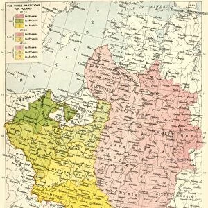
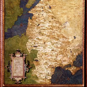
Poland, 1815-1914, (c1920). Creator: John Bartholomew & Son
. Creator: John Bartholomew & Son")
![]()
Wall Art and Photo Gifts from Heritage Images
Poland, 1815-1914, (c1920). Creator: John Bartholomew & Son
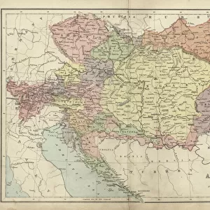
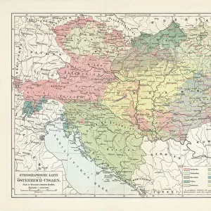
Poland, 1815-1914, (c1920). Map showing Polish territory from the end of the 18th century until the First World War: Poland as constituted in 1815, and Poland before partition of 1772. From " The Great World War - A History" Volume IV, edited by Frank A Mumby. [The Gresham Publishing Company Ltd, London, c1920]
Heritage Images features heritage image collections
Media ID 19174389
© The Print Collector/Heritage Images
Austro Hungarian Empire Baltic Sea Bartholomew Bartholomew And Co Bartholomew Co Bartholomew John Son Commonwealth Disputed Territory Frank Arthur Frank Arthur Mumby Galicia Gresham Publishing Co Ltd Gresham Publishing Company Imperial Imperialism Jg Bartholomew John And Son John Bartholomew And Co John Bartholomew And Son John Bartholomew And Son Ltd John Bartholomew Co John Bartholomew Son John Bartholomew Son Ltd John Son Keystone Archives Lithuania Mumby Mumby Frank Arthur Occupied Territory Partition Poland Prussia Prussian Territorial Territory The Great World War A History Theatre Of War Ukraine
FEATURES IN THESE COLLECTIONS
> Europe
> Austria
> Related Images
> Europe
> Hungary
> Related Images
> Europe
> Lithuania
> Posters
> Europe
> Lithuania
> Related Images
EDITORS COMMENTS
This photo print, titled "Poland, 1815-1914" takes us on a journey through the tumultuous history of Poland during the 19th and early 20th centuries. Created by John Bartholomew & Son around 1920, this map showcases Polish territory from the late 18th century until the outbreak of World War I. The map provides a visual representation of Poland's complex geopolitical landscape during this period. It highlights two significant moments in Polish history: Poland as it existed in 1815 and Poland before its partition in 1772. The vibrant colors used to depict various regions add depth to our understanding of this diverse country. As we explore this historical artifact, we are reminded of the profound impact that imperial powers like Austria-Hungary had on shaping Poland's borders and destiny. The disputed territories and occupied lands reflect the struggles faced by Poles throughout their fight for independence. This print is sourced from "The Great World War - A History". Volume IV, edited by Frank A Mumby, published by The Gresham Publishing Company Ltd in London. It serves as a valuable resource for historians seeking insights into Europe's political landscape leading up to one of humanity's most devastating conflicts. John Bartholomew & Son have masterfully captured not only geographical features but also concepts such as imperialism and occupation within this single image. As we gaze upon this piece, we are transported back in time to witness an era when nations were reshaped and boundaries redrawn amidst great turmoil.
MADE IN THE USA
Safe Shipping with 30 Day Money Back Guarantee
FREE PERSONALISATION*
We are proud to offer a range of customisation features including Personalised Captions, Color Filters and Picture Zoom Tools
SECURE PAYMENTS
We happily accept a wide range of payment options so you can pay for the things you need in the way that is most convenient for you
* Options may vary by product and licensing agreement. Zoomed Pictures can be adjusted in the Cart.