Home > Europe > United Kingdom > England > London > Boroughs > Hillingdon
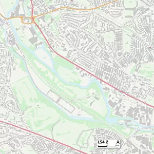
Leeds LS17 7 Map

![]()
Wall Art and Photo Gifts from Map Marketing
Leeds LS17 7 Map
Postcode Sector Map of Leeds LS17 7
Media ID 19973745
Avenue Gardens Birkdale Close Birkdale Drive Birkdale Grove Church Crescent Church Gardens Crag Lane Fir Tree Close Fir Tree Grove Fir Tree Lane Gleneagles Road Grange Court King Lane Lakeland Drive Leeds Lingfield Close Lingfield Drive Meadow Way Mount Drive Nursery Close Nursery Grove Nursery Lane Old Barn Close Sovereign Court St Andrews Drive St Andrews Walk Sunningdale Avenue Sunningdale Close Sunningdale Drive Tall Trees The Avenue The Close The Court The Crescent The Drive The Fairway The Grove The Lane The Mount The Nook The Quarry The Valley Turnberry Avenue Turnberry Close Turnberry Drive Valley Close Wentworth Avenue Wentworth Crescent Wentworth Way Windermere Drive
FEATURES IN THESE COLLECTIONS
> Europe
> United Kingdom
> England
> London
> Boroughs
> Hillingdon
> Europe
> United Kingdom
> Scotland
> Fife
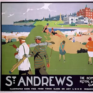
> St Andrews
> Map Marketing
> Postcode Sector Maps
> LS - Leeds
> Maps and Charts
> Related Images
MADE IN THE USA
Safe Shipping with 30 Day Money Back Guarantee
FREE PERSONALISATION*
We are proud to offer a range of customisation features including Personalised Captions, Color Filters and Picture Zoom Tools
SECURE PAYMENTS
We happily accept a wide range of payment options so you can pay for the things you need in the way that is most convenient for you
* Options may vary by product and licensing agreement. Zoomed Pictures can be adjusted in the Cart.