Home > North America > United States of America > New York > New York > Maps
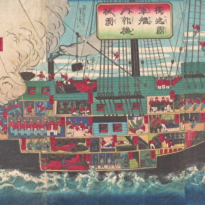
Chart of the Spanish Armadas course, 1588 (1893)
")
![]()
Wall Art and Photo Gifts from Heritage Images
Chart of the Spanish Armadas course, 1588 (1893)
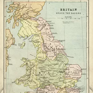
Chart of the Spanish Armadas course, 1588 (1893). Pines engraving of 1739, of a tapestry then in the House of Lords. An illustration from A Short History of the English People, by John Richard Green, illustrated edition, Volume II, Macmillan and Co, London, New York, 1893. (Colorised black and white print)
Heritage Images features heritage image collections
Media ID 14989473
© The Print Collector
British Isles Cartography Colorised Colourised Elizabethan John Richard John Richard Green Map Making Pine Route Spanish Armada Tudor Naval Warfare
FEATURES IN THESE COLLECTIONS
> Arts
> Artists
> P
> John Pine
> Arts
> Artists
> S
> Richard Short
> Arts
> Artists
> W
> John White
> Europe
> United Kingdom
> England
> Maps
> Europe
> United Kingdom
> England
> York
> Heritage Images
> Maps Charts & Plans
> Maps and Charts
> Related Images
> Maps and Charts
> Spain
> North America
> United States of America
> New York
> New York
> Maps
> North America
> United States of America
> New York
> Related Images
EDITORS COMMENTS
This print showcases a remarkable piece of history - the Chart of the Spanish Armadas course in 1588. Originally engraved by Pines in 1739, this particular illustration was featured in John Richard Green's A Short History of the English People, published in 1893. The image captures a colorised print of a tapestry that once adorned the House of Lords. The chart depicts the route taken by the Spanish Armada during its infamous campaign against England. It serves as a testament to both British naval warfare and cartography during the Tudor era. The vibrant colors breathe life into this centuries-old map, allowing us to envision how it might have appeared at its creation. As we gaze upon this historical artifact, we are transported back to an era filled with tension and conflict between two powerful nations - Spain and Britain. This visual representation offers insight into strategic planning and military movements employed during one of Europe's most significant wars. The attention to detail within this print is truly remarkable; every line meticulously drawn, every contour carefully etched. It reminds us not only of our rich heritage but also highlights the importance placed on accurate map-making throughout history. In preserving such invaluable pieces like this chart, we honor those who came before us while gaining a deeper understanding of our past. Let us cherish these artifacts as windows into forgotten worlds, forever grateful for their ability to connect us with our ancestors' triumphs and tribulations.
MADE IN THE USA
Safe Shipping with 30 Day Money Back Guarantee
FREE PERSONALISATION*
We are proud to offer a range of customisation features including Personalised Captions, Color Filters and Picture Zoom Tools
SECURE PAYMENTS
We happily accept a wide range of payment options so you can pay for the things you need in the way that is most convenient for you
* Options may vary by product and licensing agreement. Zoomed Pictures can be adjusted in the Cart.