Home > Europe > Italy > Lazio > Rome
Anglo-Saxon 10th century world map

![]()
Wall Art and Photo Gifts from Science Photo Library
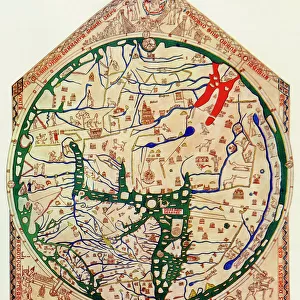
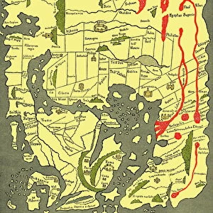
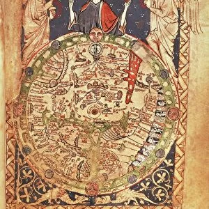
Anglo-Saxon 10th century world map
Anglo-Saxon world map, dating from the 10th century. East is top. This map of the known world was probably produced by an Irish monk. Considering the state of European learning at the time, it is an impressive geographical achievement. However, in terms of accuracy it is outclassed by maps dating from the Classical era. Important landmarks, such as Jerusalem and Rome, are marked. The original is part of the Cotton Library, held in the British Library. Taken from A Book of Discovery (1912) by M.B. Synge
Science Photo Library features Science and Medical images including photos and illustrations
Media ID 6349577
© SHEILA TERRY/SCIENCE PHOTO LIBRARY
10th Century 900s Cartography Chart Countries Country Irish Mediterranean Middle East Old World World Map British Library Mappa Mundi
FEATURES IN THESE COLLECTIONS
> Asia
> East Timor
> Maps
> Asia
> East Timor
> Related Images
> Europe
> Italy
> Lazio
> Rome
> Europe
> Related Images
> Europe
> Republic of Ireland
> Maps
> Historic
> Monuments and landmarks
> Maps and Charts
> Early Maps
> Maps and Charts
> Popular Maps
> Maps and Charts
> Related Images
> Maps and Charts
> World
> Posters
> Scientific Posters
EDITORS COMMENTS
This print showcases an extraordinary piece of history - the Anglo-Saxon 10th century world map. With its unique orientation, where east is placed at the top, this remarkable creation was believed to be crafted by a skilled Irish monk. Considering the limited knowledge and resources available during that era, this map stands as a testament to their impressive geographical achievement. While it may not match the accuracy of maps from the Classical era, this ancient artwork still holds immense value. It features significant landmarks like Jerusalem and Rome, providing insights into how these places were perceived in the 10th century. The original resides within the renowned Cotton Library at the British Library, adding to its historical significance. Transporting us back in time to an age when cartography was still developing, this illustration offers a glimpse into our ancestors' understanding of their world. From Europe to the Middle East and beyond, it presents a snapshot of known countries and regions during that period. As we explore this mesmerizing mappa mundi (world map), we can't help but appreciate both its artistic beauty and historical importance. Preserved through centuries in books like "A Book of Discovery" by M. B Synge (1912), it continues to fascinate scholars and enthusiasts alike with its portrayal of an old world long gone by.
MADE IN THE USA
Safe Shipping with 30 Day Money Back Guarantee
FREE PERSONALISATION*
We are proud to offer a range of customisation features including Personalised Captions, Color Filters and Picture Zoom Tools
SECURE PAYMENTS
We happily accept a wide range of payment options so you can pay for the things you need in the way that is most convenient for you
* Options may vary by product and licensing agreement. Zoomed Pictures can be adjusted in the Cart.