Home > Arts > Artists > S > John Speed
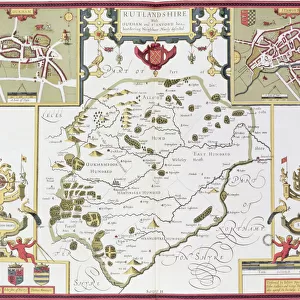
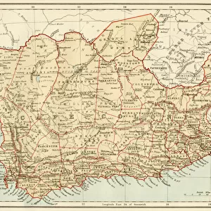
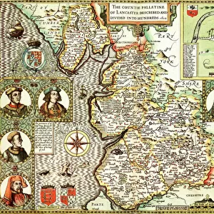
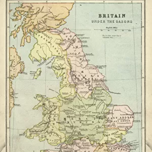
Old County Map of Rutlandshire 1611 by John Speed

![]()
Wall Art and Photo Gifts from MapSeeker
Old County Map of Rutlandshire 1611 by John Speed
A facimile of John Speeds historical map of Rutlandshire originally published for the " Theatre of the Empire of Great Britain", an atlas to accompany " a history of Great Britain"
Welcome to the Mapseeker Image library and enter an historic gateway to one of the largest on-line collections of Historic Maps, Nostalgic Views, Vista's and Panorama's from a World gone by.
Media ID 20347564
© Mapseeker Publishing Ltd
County Map County Map Of England English County Map Historic Map John Speed Map Old County Map Old English County Map Speed Map Speede Map Rutland Rutlandshire
FEATURES IN THESE COLLECTIONS
> Arts
> Artists
> S
> John Speed
> Europe
> United Kingdom
> England
> Maps
> Europe
> United Kingdom
> England
> Rutland
> Related Images
> Maps and Charts
> British Empire Maps
> Maps and Charts
> Early Maps
> Maps and Charts
> Related Images
> MapSeeker
> Maps from the British Isles
> England and Counties PORTFOLIO
EDITORS COMMENTS
This print showcases the "Old County Map of Rutlandshire 1611" by John Speed, a renowned cartographer of his time. Originally published for the "Theatre of the Empire of Great Britain" an atlas accompanying a comprehensive history of Great Britain, this facsimile takes us back to a bygone era. With its intricate details and exquisite craftsmanship, this English county map offers a glimpse into the historical landscape of Rutlandshire during the early 17th century. Every line and curve on this map tells a story, revealing ancient towns, villages, rivers, and landmarks that have shaped the region's rich heritage. John Speed's expertise in cartography is evident in every stroke he made on this masterpiece. The map not only serves as an invaluable resource for historians and geographers but also captivates art enthusiasts with its aesthetic appeal. As we gaze upon this historic Rutlandshire map, we are transported through time to explore the past. It allows us to trace our roots and understand how our ancestors navigated their world centuries ago. This piece is more than just a mere representation; it encapsulates an entire era within its borders. Whether you're fascinated by old maps or eager to uncover your local history, this print brings together artistry and knowledge in one remarkable piece. Let it be a window into another age—a testament to John Speed's skill as well as Rutlandshire's enduring legacy.
MADE IN THE USA
Safe Shipping with 30 Day Money Back Guarantee
FREE PERSONALISATION*
We are proud to offer a range of customisation features including Personalised Captions, Color Filters and Picture Zoom Tools
SECURE PAYMENTS
We happily accept a wide range of payment options so you can pay for the things you need in the way that is most convenient for you
* Options may vary by product and licensing agreement. Zoomed Pictures can be adjusted in the Cart.